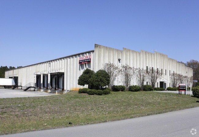
Property Record
151 Robinson Rd Nw, Calhoun, GA 30701


Property Detail
151 Robinson Rd Nw
041A-018
LT 16 ROBINSON PROPERTY
Publicstorage
Gordon
I-1
Georgia
B and X Area of moderate flood hazard, usually the area between the limits of the 100-year and 500-year floods.
16
2025
1.98 AC
2025
Georgia Northwest
970302
Other Market Areas
36,000 SF
Calhoun, GA
NEARBY LISTINGS FOR SALE OR LEASE
DEMOGRAPHICS near 151 Robinson Rd Nw
1 mile
3 mile
5 mile
2025 Total Population
830
9,100
24,803
2030 Population
895
9,662
26,110
Pop Growth 2025-2030
+ 7.83%
+ 6.18%
+ 5.27%
Average Age
35
38
39
2025 Total Households
236
3,106
9,154
HH Growth 2025-2030
+ 8.05%
+ 6.15%
+ 5.16%
Median Household Inc
$55,999
$62,547
$64,244
Avg Household Size
3.00
2.80
2.60
2025 Avg HH Vehicles
2.00
2.00
2.00
Median Home Value
$213,513
$177,705
$222,007
Median Year Built
1994
1992
1988
Nearby Places
Map Layers
Map Styles
 Street
 Aerial
Layers
 Traffic
 Biking
Places
Listings with unknown addresses are not visible on the map
- Restaurants
- Banks
- Shops
- Fitness
- Groceries
SALE & LEASE HISTORY
LISTING DATE
SALE/LEASE

Nov 15, 2017
For Sale
May 15, 2020
For Lease
Apr 05, 2018
For Lease
Apr 05, 2018
For Sale
Nearby Properties
Address
Land Use
TOTAL SIZE
Lot Size
Zoning
Address
Land Use
TOTAL SIZE
Lot Size
Zoning
46,786 SF
62.41 AC
A-1
Address
Land Use
TOTAL SIZE
Lot Size
Zoning
11,050 SF
12.35 AC
A-1
Address
Land Use
TOTAL SIZE
Lot Size
Zoning
214,593 SF
11.21 AC
IND-G
Address
Land Use
TOTAL SIZE
Lot Size
Zoning
15,360 SF
38.58 AC
A-1
Address
Land Use
TOTAL SIZE
Lot Size
Zoning
292,776 SF
9 AC
IND-G
Address
Land Use
TOTAL SIZE
Lot Size
Zoning
181,728 SF
9.13 AC
IND-G
Address
Land Use
TOTAL SIZE
Lot Size
Zoning
43.19 AC
A-1
Address
Land Use
TOTAL SIZE
Lot Size
Zoning
12,692 SF
10.08 AC
C-2
Address
Land Use
TOTAL SIZE
Lot Size
Zoning
95,476 SF
13.70 AC
IND-G
Address
Land Use
TOTAL SIZE
Lot Size
Zoning
92,500 SF
6.78 AC
I-1
Address
Land Use
TOTAL SIZE
Lot Size
Zoning
310.65 AC
A-1
Address
Land Use
TOTAL SIZE
Lot Size
Zoning
42,010 SF
2.36 AC
R-2
Address
Land Use
TOTAL SIZE
Lot Size
Zoning
24,781 SF
11 AC
IND-G
Address
Land Use
TOTAL SIZE
Lot Size
Zoning
67.34 AC
C-G
Address
Land Use
TOTAL SIZE
Lot Size
Zoning
400 AC
A-1
Address
Land Use
TOTAL SIZE
Lot Size
Zoning
1,216 SF
113.75 AC
A-1
Address
Land Use
TOTAL SIZE
Lot Size
Zoning
35,176 SF
14.42 AC
C-2
Address
Land Use
TOTAL SIZE
Lot Size
Zoning
20,785 SF
5.95 AC
Address
Land Use
TOTAL SIZE
Lot Size
Zoning
5,440 SF
5.16 AC
R-2
Address
Land Use
TOTAL SIZE
Lot Size
Zoning
157,224 SF
6.78 AC
IND-G
Address
Land Use
TOTAL SIZE
Lot Size
Zoning
25,365 SF
11 AC
IND-G
Address
Land Use
TOTAL SIZE
Lot Size
Zoning
235.38 AC
A-1
Address
Land Use
TOTAL SIZE
Lot Size
Zoning
508.87 AC
A-1
Address
Land Use
TOTAL SIZE
Lot Size
Zoning
436.51 AC
A-1
Address
Land Use
TOTAL SIZE
Lot Size
Zoning
20,641 SF
4.61 AC
C-2
Address
Land Use
TOTAL SIZE
Lot Size
Zoning
119,026 SF
14.50 AC
IND-G
Address
Land Use
TOTAL SIZE
Lot Size
Zoning
8,720 SF
1.38 AC
R-2
Address
Land Use
TOTAL SIZE
Lot Size
Zoning
52,640 SF
9.70 AC
IND-G
Address
Land Use
TOTAL SIZE
Lot Size
Zoning
97,600 SF
16.44 AC
IND-G
Address
Land Use
TOTAL SIZE
Lot Size
Zoning
7,280 SF
5.81 AC
IND-G
The World's #1 Commercial Real Estate Marketplace
Connect with us
© 2026 CoStar Group
The information above has been obtained from sources believed reliable. While we do not doubt its accuracy we have not verified it and make no guarantee, warranty or representation about it. It is your responsibility to independently confirm its accuracy and completeness. Any projections, opinions, assumptions, or estimates used are for example only and do not represent the current or future performance of the property. The value of this transaction to you depends on tax and other factors which should be evaluated by your tax, financial, and legal advisors. You and your advisors should conduct a careful, independent investigation of the property to determine to your satisfaction the suitability of the property for your needs.